
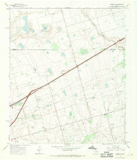
1966 Map of North Curtis Ranch
USGS Topo · Published 1968About this map
Isolated ranching operations and water infrastructure define this mid-1960s landscape in Martin County. The cattle-driven economy of the High Plains is evident through a dense network of named water sources and windmills, including Broke Leg Windmill and the colorfully named Powder Puff Windmill. While North Curtis Ranch and Glass Ranch serve as primary hubs, the terrain is also marked by modern industrial development, such as the Radio Tower Relay and multiple pipelines crossing the plains.
Find a feature on this map
27 named features on this map. Tap any name to fly to it.
Don’t see what you’re looking for? This feature index may not catch every label — zoom into the map to look around manually.
Map Details
Editions of this 1966 North Curtis Ranch Map
This is the sole edition of this map. No revisions or reprints were ever made.
Other maps of this area

1954 · Hobbs
USGS Topo · 1:250,000

1954 · Big Spring
USGS Topo · 1:250,000

1958 · Big Spring
USGS Topo · 1:250,000

1958 · Hobbs
USGS Topo · 1:250,000

1965 · Northeast Midland
USGS Topo · 1:24,000

1966 · Lenorah West
USGS Topo · 1:24,000

1966 · Mabee Ranch
USGS Topo · 1:24,000

1966 · Flynt Ranch
USGS Topo · 1:24,000

1966 · Bird Ranch
USGS Topo · 1:24,000
1966 · Germania
USGS Topo · 1:24,000