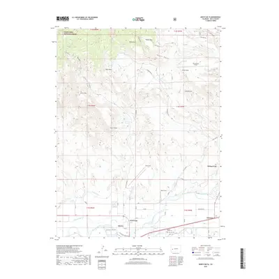
2019 Map of North Delta
USGS Topo · Published 2019About this map
The Gunnison River and Tongue Cr confluence anchors this landscape, where the agricultural flats of Delta and North Delta meet the rising plateaus of the western slope. A sophisticated network of irrigation infrastructure, including the Hartland Ditch, N Delta Canal, and Bona Fide Ditch, underscores the region's reliance on water management for its orchards and fields. To the north, the terrain transitions into a series of named mesas and volcanic features, such as Beebe Mesa, Doctor Mesa, and the distinctive Devils Thumb. This 2019 survey documents the expansion of Orchard City and the importance of local aviation at Blake Field. The map provides excellent genealogical detail with the location of Memory Gardens Cem and Mesa View Cem, alongside recreational access through the Confluence Lake Trails near the riverbanks.
Find a feature on this map
55 named features on this map. Tap any name to fly to it.
Don’t see what you’re looking for? This feature index may not catch every label — zoom into the map to look around manually.
Map Details
Editions of this 2019 North Delta Map
This is the sole edition of this map. No revisions or reprints were ever made.
Other maps of this area

1955 · Olathe NW
USGS Topo · 1:24,000

1956 · Montrose
USGS Topo · 1:250,000

1956 · Moab
USGS Topo · 1:250,000

1959 · Moab
USGS Topo · 1:250,000

1959 · Montrose
USGS Topo · 1:250,000

1960 · Montrose
USGS Topo · 1:250,000

1960 · Moab
USGS Topo · 1:250,000

1962 · Moab
USGS Topo · 1:250,000
1962 · North Delta
USGS Topo · 1:24,000
1962 · Orchard City
USGS Topo · 1:24,000