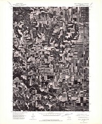
1975 Map of North Freedom SE
USGS Topo · Published 1976About this map
Badger occupies the northeast corner of this orthophotoquad, showing the geometric layout of the massive industrial and military facility during the mid-1970s. The landscape of Sauk County is otherwise defined by an intricate network of agricultural fields and woodlots, where contour plowing and strip cropping patterns are clearly visible across the undulating terrain. Toward the southern portion of the image, the Lodi Mill site stands along a winding stream corridor, representing the small-scale industrial history of the rural region. Unlike a standard topographic map, this aerial survey provides a direct visual record of the land use and forest cover exactly as it appeared in 1975, capturing the density of timber in the ravines and the precise boundaries of family farms.
Find a feature on this map
2 named features on this map. Tap any name to fly to it.
Don’t see what you’re looking for? This feature index may not catch every label — zoom into the map to look around manually.
Map Details
Editions of this 1975 North Freedom SE Map
2 editions found
Other maps of this area

1895 · Baraboo
USGS Topo · 1:62,500

1901 · Denzer
USGS Topo · 1:62,500

1907 · Cross Plains
USGS Topo · 1:62,500

1908 · Baraboo
USGS Topo · 1:62,500

1909 · Cross Plains
USGS Topo · 1:62,500

1920 · Blue Mounds
USGS Topo · 1:62,500

1922 · Blue Mounds
USGS Topo · 1:62,500

1957 · Madison
USGS Topo · 1:250,000

1958 · North Freedom
USGS Topo · 1:62,500

1959 · Baraboo
USGS Topo · 1:62,500