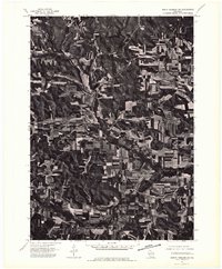
1975 Map of North Freedom SW
USGS Topo · Published 1976About this map
Leland sits near the center of this orthophotoquad, which emphasizes the striking agricultural patterns of Sauk County in the mid-1970s. This aerial perspective, captured in May 1975, reveals how the area's rural landscape was defined by sharp contrasts between wooded ridges and cultivated valley floors. The small settlements of Black Hawk, Witwen, and Denzer are visible as clusters of structures amidst a mosaic of farm fields. Because this is an orthophotograph, researchers can see the exact density of woodlands and the precise layout of farmsteads as they existed at the time of the flight. The visual data provides a clear record of land use, showing how local roads followed the natural contours of the Wisconsin terrain to connect these isolated rural communities.
Find a feature on this map
4 named features on this map. Tap any name to fly to it.
Don’t see what you’re looking for? This feature index may not catch every label — zoom into the map to look around manually.
Map Details
Editions of this 1975 North Freedom SW Map
2 editions found
Other maps of this area

1901 · Denzer
USGS Topo · 1:62,500

1905 · Richland Center
USGS Topo · 1:125,000

1920 · Blue Mounds
USGS Topo · 1:62,500

1922 · Blue Mounds
USGS Topo · 1:62,500

1957 · Madison
USGS Topo · 1:250,000

1958 · North Freedom
USGS Topo · 1:62,500

1958 · La Crosse
USGS Topo · 1:250,000

1960 · Madison
USGS Topo · 1:250,000

1960 · Plain
USGS Topo · 1:62,500

1960 · Spring Green
USGS Topo · 1:62,500