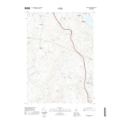
2021 Map of North Grantham
USGS Topo · Published 2021About this map
Lower Shaker Village and Upper Shaker Village sit along the southwestern shore of Mascoma Lake, marking the historical presence of the Shaker community in this portion of Grafton County. This upland landscape is defined by a series of prominent peaks, including Shaker Mtn, Methodist Hill, and the high ridgeline of Croydon Mtn. The boundary between Grafton and Sullivan counties cuts across the rugged center of the map, separating the northern settlements near Lebanon from the southern reaches of North Grantham. Numerous small water bodies such as Lily Pond, Miller Pond, and Grass Pond are scattered throughout the hills, feeding a network of drainages like Skinner Brook and Newton Brook. Local history is preserved in small burial grounds like Follensbee Cem and Purmort Cem, while old thoroughfares like the Croydon Tpke provide evidence of early travel routes through the New Hampshire interior.
Find a feature on this map
78 named features on this map. Tap any name to fly to it.
Don’t see what you’re looking for? This feature index may not catch every label — zoom into the map to look around manually.
Map Details
Editions of this 2021 North Grantham Map
This is the sole edition of this map. No revisions or reprints were ever made.
Other maps of this area

1902 · Sunapee
USGS Topo · 1:62,500

1905 · Sunapee
USGS Topo · 1:62,500

1906 · Hanover
USGS Topo · 1:62,500

1907 · Sunapee
USGS Topo · 1:62,500

1908 · Hanover
USGS Topo · 1:62,500

1926 · Claremont
USGS Topo · 1:62,500

1927 · Mascoma
USGS Topo · 1:62,500

1929 · Claremont
USGS Topo · 1:62,500

1932 · Mascoma
USGS Topo · 1:62,500

1950 · Glens Falls
USGS Topo · 1:250,000