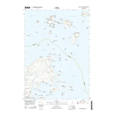
2014 Map of North Haven East
USGS Topo · Published 2014About this map
The town of North Haven and the surrounding islands of East Penobscot Bay are documented here in the early twenty-first century. This coastal landscape is defined by its maritime heritage and dispersed family settlements, indicated by numerous small burial grounds such as Browns Cem, Frye Cem, and Kent Cem. The interior of the main landmass is crisscrossed by roads like Middle Rd and N Shore Rd, connecting local landmarks such as Fresh Pond and Charley Browns Pond.
Find a feature on this map
130 named features on this map. Tap any name to fly to it.
Don’t see what you’re looking for? This feature index may not catch every label — zoom into the map to look around manually.
Map Details
Editions of this 2014 North Haven East Map
This is the sole edition of this map. No revisions or reprints were ever made.
Other maps of this area

1902 · Castine
USGS Topo · 1:62,500

1904 · Deer Isle
USGS Topo · 1:62,500

1904 · Castine
USGS Topo · 1:62,500

1904 · Bluehill
USGS Topo · 1:62,500

1904 · Vinalhaven
USGS Topo · 1:62,500

1905 · Penobscot Bay
USGS Topo · 1:125,000

1941 · Castine
USGS Topo · 1:62,500

1941 · Vinalhaven
USGS Topo · 1:62,500

1942 · Deer Isle
USGS Topo · 1:62,500
1943 · Castine
USGS Topo · 1:62,500