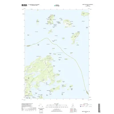
2018 Map of North Haven East
USGS Topo · Published 2018About this map
North Haven and its surrounding archipelago define this coastal Maine landscape where Penobscot Bay meets the Atlantic Ocean. The settlement pattern is largely concentrated on the southern island, connected by a network of local routes like Pulpit Harbor Rd and S Shore Rd. For genealogists and family historians, several small burial grounds are documented across the terrain, including Browns Cem, Frye Cem, and Seaview Cem. The coastline is heavily indented with features such as Pulpit Harbor, Marsh Cove, and Waterman Cove, indicating the area's long-standing reliance on maritime access. Further north, the survey details dozens of smaller landmasses like Butter Island, Bear Island, and Bradbury Island, many featuring individual beaches and landings. The presence of Witherspoons Landing Strip, Inc reflects the modern aviation infrastructure required for these relatively isolated island communities.
Find a feature on this map
128 named features on this map. Tap any name to fly to it.
Don’t see what you’re looking for? This feature index may not catch every label — zoom into the map to look around manually.
Map Details
Editions of this 2018 North Haven East Map
This is the sole edition of this map. No revisions or reprints were ever made.
Other maps of this area

1902 · Castine
USGS Topo · 1:62,500

1904 · Deer Isle
USGS Topo · 1:62,500

1904 · Castine
USGS Topo · 1:62,500

1904 · Bluehill
USGS Topo · 1:62,500

1904 · Vinalhaven
USGS Topo · 1:62,500

1905 · Penobscot Bay
USGS Topo · 1:125,000

1941 · Castine
USGS Topo · 1:62,500

1941 · Vinalhaven
USGS Topo · 1:62,500

1942 · Deer Isle
USGS Topo · 1:62,500
1943 · Castine
USGS Topo · 1:62,500