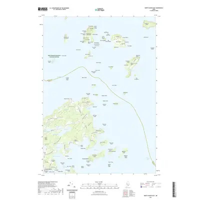
2021 Map of North Haven East
USGS Topo · Published 2021About this map
Penobscot Bay surrounds a complex archipelago where family history is deeply rooted in the soil and shoreline. The settlement of North Haven serves as a southern anchor, while the surrounding landscape is marked by numerous family burial grounds, including Old Brown Cem, Frye Cem, and Witherspoon Cem on Butter Island. The terrain is characterized by intricate water bodies like Pulpit Harbor and Fresh Pond, alongside low-lying wetlands such as Purgatory Swamp. Transportation on the islands relies on a network of local roads like Oak Hill Rd and Mullens Head Rd. The mapping of small islands such as Eagle Island and Bradbury Island highlights the maritime isolation and self-sufficiency of these coastal communities. To the northwest, a portion of the Petit Manan National Wildlife Refuge encompasses Compass Island, preserving the natural character of these outlying ledges.
Find a feature on this map
132 named features on this map. Tap any name to fly to it.
Don’t see what you’re looking for? This feature index may not catch every label — zoom into the map to look around manually.
Map Details
Editions of this 2021 North Haven East Map
This is the sole edition of this map. No revisions or reprints were ever made.
Other maps of this area

1902 · Castine
USGS Topo · 1:62,500

1904 · Deer Isle
USGS Topo · 1:62,500

1904 · Castine
USGS Topo · 1:62,500

1904 · Bluehill
USGS Topo · 1:62,500

1904 · Vinalhaven
USGS Topo · 1:62,500

1905 · Penobscot Bay
USGS Topo · 1:125,000

1941 · Castine
USGS Topo · 1:62,500

1941 · Vinalhaven
USGS Topo · 1:62,500

1942 · Deer Isle
USGS Topo · 1:62,500
1943 · Castine
USGS Topo · 1:62,500