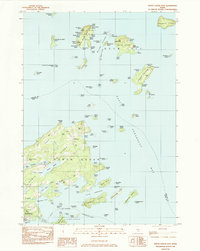
1982 Map of North Haven East
USGS Topo · Published 1983About this map
The coastal island architecture of Knox County and Hancock County is defined by a dense archipelago in the Penobscot Bay. The landscape is dotted with ancestral landmarks, including the Seaview Cem, Brown Cem, and Frye Cem, which speak to the long-standing maritime families of North Haven. Navigational markers like the Goose Rocks Lighthouse and the North Haven Ferry route emphasize the reliance on the Fox Islands Thorofare for local transit and commerce. Notable settlements and clearings, such as The Wood Landing on Eagle Island and the Watson Landing Strip on the main island, show how the community balanced traditional boat access with modern aviation needs during the early 1980s. The map reveals a mixture of working waterfronts and protected spaces, including a Wildlife Management Area on Grass Ledge.
Find a feature on this map
119 named features on this map. Tap any name to fly to it.
Don’t see what you’re looking for? This feature index may not catch every label — zoom into the map to look around manually.
Map Details
Editions of this 1982 North Haven East Map
This is the sole edition of this map. No revisions or reprints were ever made.
Other maps of this area

1902 · Castine
USGS Topo · 1:62,500

1904 · Deer Isle
USGS Topo · 1:62,500

1904 · Castine
USGS Topo · 1:62,500

1904 · Bluehill
USGS Topo · 1:62,500

1904 · Vinalhaven
USGS Topo · 1:62,500

1905 · Penobscot Bay
USGS Topo · 1:125,000

1941 · Castine
USGS Topo · 1:62,500

1941 · Vinalhaven
USGS Topo · 1:62,500

1942 · Deer Isle
USGS Topo · 1:62,500
1943 · Castine
USGS Topo · 1:62,500