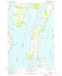
1966 Map of North Hero
USGS Topo · Published 1976About this map
Isle La Motte and the elongated North Hero islands dominate this mid-century landscape in the heart of Lake Champlain. The map illustrates a period of transition, where the legacy of the Old Railroad Grade and Old Grade Railroad cutting through the Alburg Tongue sits alongside recreational landmarks like Camp Abnaki and several roadside parks. Family names and local history are preserved in features like Jerusalem Cem, Fisk Point, and Hazen Point.
Find a feature on this map
84 named features on this map. Tap any name to fly to it.
Don’t see what you’re looking for? This feature index may not catch every label — zoom into the map to look around manually.
Map Details
Editions of this 1966 North Hero Map
3 editions found
Other maps of this area

1894 · Plattsburg
USGS Topo · 1:62,500

1895 · Rouse Point
USGS Topo · 1:62,500

1906 · Plattsburg
USGS Topo · 1:62,500

1907 · Rouse Point
USGS Topo · 1:62,500

1913 · Milton
USGS Topo · 1:48,000

1914 · St. Albans
USGS Topo · 1:48,000

1915 · Milton
USGS Topo · 1:62,500

1916 · St. Albans
USGS Topo · 1:62,500

1939 · Rouses Point
USGS Topo · 1:62,500

1939 · Plattsburg
USGS Topo · 1:62,500