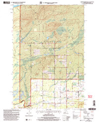
1999 Map of North Ironwood
USGS Topo · Published 2004About this map
Ottawa National Forest blankets the northern portion of this terrain as it approaches the rocky shoreline of Lake Superior. The landscape is a network of drainage systems, including Ironwood Creek, Mud Creek, and Spring Creek, which wind through the forested sections and small clearings of the Upper Peninsula. Along the southern border, the Montreal River defines the state line between Michigan and Wisconsin, separating Gogebic and Iron Counties.
Find a feature on this map
34 named features on this map. Tap any name to fly to it.
Don’t see what you’re looking for? This feature index may not catch every label — zoom into the map to look around manually.
Map Details
Editions of this 1999 North Ironwood Map
This is the sole edition of this map. No revisions or reprints were ever made.
Other maps of this area

1940 · Upson
USGS Topo · 1:48,000

1943 · Little Girls Point
USGS Topo · 1:24,000

1943 · Upson
USGS Topo · 1:48,000

1943 · Ironwood
USGS Topo · 1:48,000

1943 · Little Girl Point
USGS Topo · 1:48,000

1953 · Ashland
USGS Topo · 1:250,000

1955 · Ironwood
USGS Topo · 1:24,000

1955 · Bessemer
USGS Topo · 1:24,000

1955 · Ironwood
USGS Topo · 1:62,500

1956 · North Ironwood
USGS Topo · 1:62,500