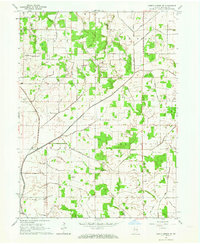
1962 Map of North Judson SE
USGS Topo · Published 1964About this map
Agricultural development in the early 1960s defines this landscape in northwestern Indiana, where a complex network of drainage canals like Tetzloff Ditch, Lizenby Ditch, and Stromberg Ditch made the land viable for farming. The map reveals a rural society structured by family-named roads and institutions, including Little Alva Ch, St Johns Ch, and several small burial grounds such as Bowman Cem and Sutton Cem. The intersection of the Monon Railroad and Big Monon Railroad provided vital transit for the area's agricultural output. Numerous gravel pits and the presence of a Pipeline signify the industrial and infrastructural growth occurring between the townships of Cass, Rich Grove, and White Post. This survey captures the region just as modern surveying techniques began recording the fine details of fence lines and field boundaries across the flat Indiana plains.
Find a feature on this map
42 named features on this map. Tap any name to fly to it.
Don’t see what you’re looking for? This feature index may not catch every label — zoom into the map to look around manually.
Map Details
Editions of this 1962 North Judson SE Map
This is the sole edition of this map. No revisions or reprints were ever made.
Other maps of this area

1953 · Chicago
USGS Topo · 1:250,000

1953 · Danville
USGS Topo · 1:250,000

1955 · Danville
USGS Topo · 1:250,000

1956 · Danville
USGS Topo · 1:250,000

1957 · Chicago
USGS Topo · 1:250,000

1959 · North Judson
USGS Topo · 1:24,000

1959 · San Pierre
USGS Topo · 1:24,000

1962 · Buffalo
USGS Topo · 1:24,000

1962 · Monon NE
USGS Topo · 1:24,000

1962 · Medaryville
USGS Topo · 1:24,000