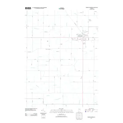
2013 Map of North Judson
USGS Topo · Published 2013About this map
North Judson serves as the primary hub of activity in this Starke County landscape, defined by a meticulously planned network of rural drainage and agricultural land. The town center is organized around a grid including Main St, Franklin St, and Railroad St, reflecting its historical development alongside transportation corridors. Outside the town, the land is dominated by significant agricultural operations such as Lukac Farms and Rozhon Farm, supported by an extensive system of man-made watercourses like Big Monon Ditch, Green Ditch, and Scholtz Ditch. These ditches underscore the region's managed hydrology, transforming the low-lying terrain into productive farmland. Aviation is represented by Crawford Field Airport, situated centrally among the fields. This survey captures a moment of modern agricultural stability where natural features like Pine Creek and Keller Arm intersect with the rigid geometry of county roads and drainage works.
Find a feature on this map
91 named features on this map. Tap any name to fly to it.
Don’t see what you’re looking for? This feature index may not catch every label — zoom into the map to look around manually.
Map Details
Editions of this 2013 North Judson Map
This is the sole edition of this map. No revisions or reprints were ever made.
Other maps of this area

1953 · Chicago
USGS Topo · 1:250,000

1957 · Chicago
USGS Topo · 1:250,000

1957 · Knox West
USGS Topo · 1:24,000

1958 · La Crosse
USGS Topo · 1:24,000

1959 · English Lake
USGS Topo · 1:24,000

1959 · North Judson
USGS Topo · 1:24,000

1959 · San Pierre
USGS Topo · 1:24,000

1962 · Medaryville
USGS Topo · 1:24,000

1962 · Denham
USGS Topo · 1:24,000
1962 · Ripley
USGS Topo · 1:24,000