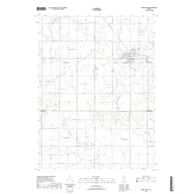
2019 Map of North Judson
USGS Topo · Published 2019About this map
The town of North Judson serves as the primary hub of this northern Indiana landscape, where a dense grid of agricultural drainage reflects the region's history of reclaiming marshland for farming. The map reveals an intricate network of waterways including Monon Ditch, Payne Ditch, and Sharp Ditch, which channel water across the flat terrain. This managed hydrology was essential for the development of the area's productive fields and the expansion of the town. Outside the central grid of North Judson, the landscape is dotted with local landmarks such as Highland Cem and Saint Jacob Cem, providing valuable points of reference for genealogists tracing family histories in the region. The map also shows significant transport routes like the Rensselaer Trl, which connect these rural communities. The distinct boundary between Starke Co and Pulaski Co runs east-to-west across the lower third of the survey, marking the political division of these fertile farmlands.
Find a feature on this map
57 named features on this map. Tap any name to fly to it.
Don’t see what you’re looking for? This feature index may not catch every label — zoom into the map to look around manually.
Map Details
Editions of this 2019 North Judson Map
This is the sole edition of this map. No revisions or reprints were ever made.
Other maps of this area

1953 · Chicago
USGS Topo · 1:250,000

1957 · Chicago
USGS Topo · 1:250,000

1957 · Knox West
USGS Topo · 1:24,000

1958 · La Crosse
USGS Topo · 1:24,000

1959 · English Lake
USGS Topo · 1:24,000

1959 · North Judson
USGS Topo · 1:24,000

1959 · San Pierre
USGS Topo · 1:24,000

1962 · Medaryville
USGS Topo · 1:24,000

1962 · Denham
USGS Topo · 1:24,000
1962 · Ripley
USGS Topo · 1:24,000