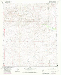
1967 Map of North Lake
USGS Topo · Published 1982About this map
North Lake and the winding course of Arroyo del Macho characterize this high-desert landscape in Lincoln County. The mapping reveals a ranching economy reliant on scattered water sources such as Lafferty Well, Percella Tank, and Sec Tank. While human settlements are sparse, the presence of the McNally Ranch, McGinnis, and Johnson Ranch indicate the established family ranching operations of the mid-20th century.
Find a feature on this map
16 named features on this map. Tap any name to fly to it.
Don’t see what you’re looking for? This feature index may not catch every label — zoom into the map to look around manually.
Map Details
Editions of this 1967 North Lake Map
2 editions found
Other maps of this area

1936 · Arabela
USGS Topo · 1:48,000

1942 · Arabela
USGS Topo · 1:62,500

1955 · Roswell
USGS Topo · 1:250,000

1958 · Roswell
USGS Topo · 1:250,000

1962 · Roswell
USGS Topo · 1:250,000

1967 · Round Mountain SE
USGS Topo · 1:24,000

1967 · North Lake
USGS Topo · 1:24,000

1967 · White Flat
USGS Topo · 1:24,000

1967 · Round Mountain
USGS Topo · 1:24,000

1967 · Chivata Canyon
USGS Topo · 1:24,000