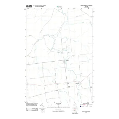
2010 Map of North Lawrence
USGS Topo · Published 2010About this map
North Lawrence and Lawrenceville serve as the primary hubs in this part of Saint Lawrence County, where the meandering Deer River dictates the local geography. The area is defined by a dense network of country roads named for local families and early settlers, leading to several established hamlets like Coteys Corner, Laverys Corner, and McEwens Corner.
Find a feature on this map
46 named features on this map. Tap any name to fly to it.
Don’t see what you’re looking for? This feature index may not catch every label — zoom into the map to look around manually.
Map Details
Editions of this 2010 North Lawrence Map
This is the sole edition of this map. No revisions or reprints were ever made.
Other maps of this area

1906 · Massena
USGS Topo · 1:62,500

1907 · Massena
USGS Topo · 1:62,500

1908 · Potsdam
USGS Topo · 1:62,500

1915 · Moira
USGS Topo · 1:62,500

1917 · Moira
USGS Topo · 1:62,500

1919 · Nicholville
USGS Topo · 1:62,500

1921 · Nicholville
USGS Topo · 1:62,500
1943 · Parishville
USGS Topo · 1:31,680

1944 · Moira
USGS Topo · 1:62,500
1946 · Brasher Falls
USGS Topo · 1:24,000