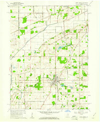
1958 Map of North Liberty
USGS Topo · Published 1961About this map
Agricultural patterns and a network of drainage ditches define this portion of St. Joseph County in the late 1950s. The town of North Liberty sits at a crossroads of the Grand Trunk and New York Central railroads, serving as a focal point for the surrounding farming townships. The landscape is marked by numerous water bodies and small lakes, including Rupel Lake, Sousley Lake, and Elizabeth Lake, many of which are connected by systems like the Tascher Ditch and Strawberry Road DITCH. Local community life is anchored by landmarks such as Westlawn Cem, Liberty Sch, and the Crumstown Ch near the northern settlement of Crumstown. The presence of the Purdue Research Farm in the western reaches of the survey highlights the region's dedication to scientific agriculture, while the Kankakee River and Potato Creek drain the fertile but low-lying terrain.
Find a feature on this map
95 named features on this map. Tap any name to fly to it.
Don’t see what you’re looking for? This feature index may not catch every label — zoom into the map to look around manually.
Map Details
Editions of this 1958 North Liberty Map
2 editions found
Other maps of this area

1953 · Chicago
USGS Topo · 1:250,000

1957 · Chicago
USGS Topo · 1:250,000

1958 · South Bend West
USGS Topo · 1:24,000

1958 · Lydick
USGS Topo · 1:24,000

1958 · La Paz
USGS Topo · 1:24,000

1958 · Hamlet
USGS Topo · 1:24,000

1958 · Walkerton
USGS Topo · 1:24,000

1958 · Stillwell
USGS Topo · 1:24,000

1958 · North Liberty
USGS Topo · 1:24,000

1958 · Lakeville
USGS Topo · 1:24,000