
1958 Map of North Liberty
USGS Topo · Published 1961About this map
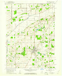
The Kankakee River valley in the late 1950s is defined by a dense network of agricultural drainage and early regional transport. The town of North Liberty serves as the primary hub, where the Wabash Railroad crosses the landscape near the Westlawn Cem and Old Cem. North of town, the terrain is dotted with small kettle lakes including Sousley Lake, Dime Lake, and Kale Lake, while the Purdue Research Farm indicates the area's ongoing importance to agricultural study. A complex system of managed waterways like Tascher Ditch and the aptly named Kartoffel Ditch illustrates the transformation of the northern Indiana wetlands into productive farmland. Smaller settlements like Crumstown and Whitmer are linked by a grid of named rural roads, such as Treaty Road and Boundary Road, which preserve the lines of early land treaties and historical township divisions.
Find a feature on this map
75 named features on this map. Tap any name to fly to it.
Don’t see what you’re looking for? This feature index may not catch every label — zoom into the map to look around manually.
Map Details
Editions of this 1958 North Liberty Map
2 editions found
Other maps of this area

1953 · Chicago
USGS Topo · 1:250,000

1957 · Chicago
USGS Topo · 1:250,000

1958 · South Bend West
USGS Topo · 1:24,000

1958 · Lydick
USGS Topo · 1:24,000

1958 · La Paz
USGS Topo · 1:24,000

1958 · Hamlet
USGS Topo · 1:24,000

1958 · Walkerton
USGS Topo · 1:24,000

1958 · Stillwell
USGS Topo · 1:24,000

1958 · Lakeville
USGS Topo · 1:24,000

1958 · New Carlisle
USGS Topo · 1:24,000