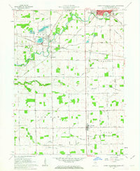
1961 Map of North Manchester South
USGS Topo · Published 1963About this map
The Eel River and its tributaries carve through the glaciated plains of Wabash County, defining the landscape of north-central Indiana during the early 1960s. The bustling town of North Manchester serves as a regional anchor in the northeast, while the smaller community of Laketon is situated near a cluster of glacial basins including Mud Lake, Long Lake, and Round Lake. The map illustrates a well-developed agricultural grid punctuated by small rural settlements like Urbana, Bolivar, and Ijamsville. A distinctive transportation network is visible where the Pennsylvania and Erie-Lackawanna railroads intersect, supporting the area's grain and livestock economy. This survey also records numerous local landmarks of value to family historians, such as Pleasant Hill Cem, Algers Cem, and the Maple Park Sch, alongside numerous family-named rural roads like Singer Road and Ulrey Road.
Find a feature on this map
55 named features on this map. Tap any name to fly to it.
Don’t see what you’re looking for? This feature index may not catch every label — zoom into the map to look around manually.
Map Details
Editions of this 1961 North Manchester South Map
3 editions found
Other maps of this area

1950 · Lagro
USGS Topo · 1:24,000

1951 · Lagro
USGS Topo · 1:24,000

1951 · Richvalley
USGS Topo · 1:24,000

1952 · Wabash
USGS Topo · 1:24,000

1953 · Fort Wayne
USGS Topo · 1:250,000

1953 · Muncie
USGS Topo · 1:250,000

1956 · Muncie
USGS Topo · 1:250,000

1956 · Fort Wayne
USGS Topo · 1:250,000

1961 · Silver Lake
USGS Topo · 1:24,000

1961 · Roann
USGS Topo · 1:24,000