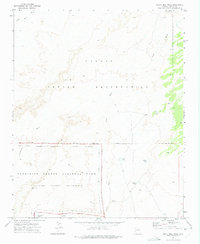
1972 Map of North Mill Well
USGS Topo · Published 1975About this map
The Navajo Indian Reservation covers the northern half of this landscape, meeting the high-desert expanse of the Petrified Forest National Park along a surveyed Indian Reservation Boundary. The terrain is defined by the drainage patterns of Wide Ruin Wash, Dead Wash, and Lithodendron Wash, which cut through the arid plains toward Padres Mesa. In the 1970s, the area's infrastructure was geared toward cattle and land management, marked by numerous water catchments like North Tank, Mark 1 Tank, and Rattlesnake Tank. A remote Jeep Trail provides the primary access through the reservation land, passing a lone Drill Hole and Corral. This survey illustrates the protected Petrified Forest Wilderness at a time when the North Mill Well served as a critical localized water source in the desert.
Find a feature on this map
19 named features on this map. Tap any name to fly to it.
Don’t see what you’re looking for? This feature index may not catch every label — zoom into the map to look around manually.
Map Details
Editions of this 1972 North Mill Well Map
This is the sole edition of this map. No revisions or reprints were ever made.
Other maps of this area

1886 · Fort Defiance
USGS Topo · 1:250,000

1892 · Fort Defiance
USGS Topo · 1:250,000

1954 · Gallup
USGS Topo · 1:250,000

1958 · Gallup
USGS Topo · 1:250,000

1959 · Gallup
USGS Topo · 1:250,000

1962 · Gallup
USGS Topo · 1:250,000

1967 · Gallup
USGS Topo · 1:250,000
1972 · Tanner Springs
USGS Topo · 1:24,000
1972 · Navajo North
USGS Topo · 1:24,000
1972 · Navajo South
USGS Topo · 1:24,000