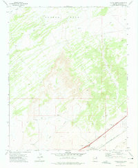
1972 Map of Navajo North
USGS Topo · Published 1975About this map
Padres Mesa dominates the northern landscape of this Apache County survey, where the high desert terrain is cut by seasonal drainages like Dead Wash and Crazy Creek. The southern corridor is defined by the vital transportation infrastructure of the early 1970s, specifically the Atchison Topeka and Santa Fe railroad line running parallel to the Puerco River. Small nodes of activity like Navajo, Marty, and the Mc Carrell site appear alongside specialized features such as a Landing Strip and various Borrow Pits, reflecting a landscape of transit and resource extraction. The presence of numerous Drill Holes and isolated water tanks suggests the ongoing efforts to manage water and mineral resources in this arid region of the Navajo Nation.
Find a feature on this map
16 named features on this map. Tap any name to fly to it.
Don’t see what you’re looking for? This feature index may not catch every label — zoom into the map to look around manually.
Map Details
Editions of this 1972 Navajo North Map
This is the sole edition of this map. No revisions or reprints were ever made.
Other maps of this area

1886 · Fort Defiance
USGS Topo · 1:250,000

1892 · Fort Defiance
USGS Topo · 1:250,000

1954 · Gallup
USGS Topo · 1:250,000

1958 · Gallup
USGS Topo · 1:250,000

1959 · Gallup
USGS Topo · 1:250,000

1962 · Gallup
USGS Topo · 1:250,000

1967 · Gallup
USGS Topo · 1:250,000
1971 · Chambers
USGS Topo · 1:24,000
1971 · Wide Ruins SW
USGS Topo · 1:24,000
1972 · Navajo Springs
USGS Topo · 1:24,000