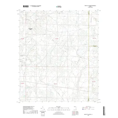
2018 Map of North of Allanton
USGS Topo · Published 2018About this map
Kent Cem stands as a quiet genealogical marker in this coastal Florida landscape, where the eastern reaches of Panama City give way to extensive wetlands. The topography is dominated by a complex network of bayous and swamps, including the large California Swamp to the southwest and Grape Swamp in the north. This 2018 survey reveals a territory defined by its hydrology, where named waterways like Cooks Bayou and Bayou George meander through low-lying terrain. While residential development is visible along streets like Dogwood Way and Fernwood Way, much of the area remains dominated by natural features like Crash Island. The map also captures the tri-county intersection where Bay, Calhoun, and Gulf counties meet, illustrating the administrative boundaries that cross this wetland-heavy environment.
Find a feature on this map
43 named features on this map. Tap any name to fly to it.
Don’t see what you’re looking for? This feature index may not catch every label — zoom into the map to look around manually.
Map Details
Editions of this 2018 North of Allanton Map
This is the sole edition of this map. No revisions or reprints were ever made.
Other maps of this area

1944 · Long Point
USGS Topo · 1:31,680

1944 · Bayhead
USGS Topo · 1:24,000

1945 · Youngstown
USGS Topo · 1:31,680

1945 · Bayhead
USGS Topo · 1:31,680

1945 · Broad Branch
USGS Topo · 1:31,680

1945 · Allanton
USGS Topo · 1:31,680

1945 · North Of Allanton
USGS Topo · 1:31,680

1945 · Wetappo Creek
USGS Topo · 1:31,680

1945 · Tenmile Swamp
USGS Topo · 1:31,680
1945 · Parker
USGS Topo · 1:31,680