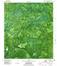
1982 Map of North Of Allanton
USGS Topo · Published 1983About this map
Bayou George and its winding tributaries define this low-lying Florida landscape during the early 1980s. The settlement at East Callaway marks the western edge of the quadrangle, where residential development begins to meet the extensive wetlands of California Swamp and the Green-Bay Swamp. A notable point of interest for local historians is the Kent Cem, situated near the confluence of several unnamed branches.
Find a feature on this map
23 named features on this map. Tap any name to fly to it.
Don’t see what you’re looking for? This feature index may not catch every label — zoom into the map to look around manually.
Map Details
Editions of this 1982 North Of Allanton Map
This is the sole edition of this map. No revisions or reprints were ever made.
Other maps of this area

1944 · Long Point
USGS Topo · 1:31,680

1944 · Bayhead
USGS Topo · 1:24,000

1945 · Youngstown
USGS Topo · 1:31,680

1945 · Bayhead
USGS Topo · 1:31,680

1945 · Broad Branch
USGS Topo · 1:31,680

1945 · Allanton
USGS Topo · 1:31,680

1945 · North Of Allanton
USGS Topo · 1:31,680

1945 · Wetappo Creek
USGS Topo · 1:31,680

1945 · Tenmile Swamp
USGS Topo · 1:31,680
1945 · Parker
USGS Topo · 1:31,680