
1995 Map of North Of Fiftymile Bend
USGS Topo · Published 1999About this map
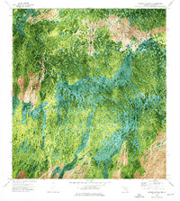
Big Cypress National Preserve defines this portion of the Florida Everglades, where a subtle mosaic of cypress strands, wet prairies, and hardwood hammocks creates a specialized ecosystem in Collier County. The 1995 planimetry highlights the preservation of this wilderness area, notably featuring a singular Hammock in the northern reaches and Threemile Island to the south. Transportation is minimal, focused on the Corn Dance Trail as it cuts through the southeast corner of the quadrangle. This survey reveals the character of the preserve before major modern alterations, showing the vast interconnected wetlands and isolated higher grounds that supported local Indigenous and pioneer history.
Find a feature on this map
5 named features on this map. Tap any name to fly to it.
Don’t see what you’re looking for? This feature index may not catch every label — zoom into the map to look around manually.
Map Details
Editions of this 1995 North Of Fiftymile Bend Map
This is the sole edition of this map. No revisions or reprints were ever made.
Other maps of this area

1956 · Miami
USGS Topo · 1:250,000

1956 · West Palm Beach
USGS Topo · 1:250,000

1957 · West Palm Beach
USGS Topo · 1:250,000

1958 · West Palm Beach
USGS Topo · 1:250,000

1958 · Miami
USGS Topo · 1:250,000
1972 · Monroe Station NE
USGS Topo · 1:24,000
1973 · Fortymile Bend
USGS Topo · 1:24,000
1973 · Fiftymile Bend
USGS Topo · 1:24,000
1973 · North Of Fiftymile Bend
USGS Topo · 1:24,000

1973 · Monroe Station
USGS Topo · 1:24,000