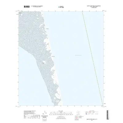
2022 Map of North of Port Isabel SW
USGS Topo · Published 2022About this map
Padre Island dominates this coastal landscape, revealing the barrier island's intricate topography along the southern Texas coast. This survey illustrates the dynamic nature of the shoreline where the Gulf of Mexico meets the sand and wetlands of Cameron County. Notable terrain features such as La Punta Larga and the shifting shoals of Los Bancos de en Medio highlight the unique geomorphology of the area. These landforms, alongside Los Tanques, demonstrate the narrow strip of land that protects the mainland from the open sea, providing a detailed look at the island's composition before further environmental changes or development might occur.
Find a feature on this map
5 named features on this map. Tap any name to fly to it.
Don’t see what you’re looking for? This feature index may not catch every label — zoom into the map to look around manually.
Map Details
Editions of this 2022 North of Port Isabel SW Map
This is the sole edition of this map. No revisions or reprints were ever made.
Other maps of this area

1929 · La Coma
USGS Topo · 1:24,000

1929 · Buena Vista
USGS Topo · 1:24,000

1930 · Padre Island No. 1
USGS Topo · 1:24,000

1930 · Padre Island No. 2
USGS Topo · 1:24,000

1934 · La Coma
USGS Topo · 1:31,680

1935 · Padre Island No 1
USGS Topo · 1:31,680

1935 · Padre Island NO. 2
USGS Topo · 1:31,680

1935 · Buena Vista
USGS Topo · 1:31,680

1952 · Green Island
USGS Topo · 1:24,000
1952 · North Of Port Isabel NW
USGS Topo · 1:24,000