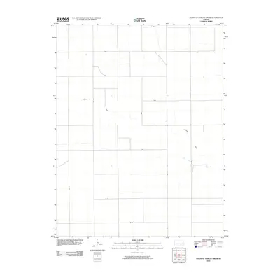
2010 Map of North of Shirley Creek
USGS Topo · Published 2010About this map
Mattox Draw defines the drainage pattern of this high plains landscape in Kearny County, cutting a winding path through an otherwise orderly grid of section lines and gravel roads. This 2010 survey illustrates the vast agricultural geometry of western Kansas, where transportation is dictated by long, straight thoroughfares such as Rd 10 and Rd W. The intersection of drainage and infrastructure is visible where the draw crosses Rd 6 and RD Z, creating subtle topographical variations in an area primarily shaped by large-scale farming. Other local connectors like Co Rd B and Rd A provide the primary access to the scattered homesteads and industrial agricultural sites that characterize the region north of the Arkansas River valley.
Find a feature on this map
16 named features on this map. Tap any name to fly to it.
Don’t see what you’re looking for? This feature index may not catch every label — zoom into the map to look around manually.
Map Details
Editions of this 2010 North of Shirley Creek Map
This is the sole edition of this map. No revisions or reprints were ever made.
Other maps of this area

1955 · Scott City
USGS Topo · 1:250,000

1958 · Scott City
USGS Topo · 1:250,000

1965 · Leoti 3 NW
USGS Topo · 1:24,000

1966 · Tribune 4 NW
USGS Topo · 1:24,000
1966 · Leoti 3 SW
USGS Topo · 1:24,000
1966 · Tribune 4 SE
USGS Topo · 1:24,000

1966 · Tribune 4 NE
USGS Topo · 1:24,000
1966 · Tribune 4 SW
USGS Topo · 1:24,000

1970 · Selkirk SW
USGS Topo · 1:24,000

1970 · Selkirk SE
USGS Topo · 1:24,000