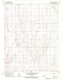
1966 Map of Tribune 4 SW
USGS Topo · Published 1967About this map
Sand Creek and Syracuse Creek carve through the landscape of western Kansas in this mid-1960s study, revealing a region defined by energy extraction and light aviation. The presence of numerous Gas Well sites scattered across the townships of Liberty, Syracuse, and Kendall reflects the industrial development of the Hugoton Gas Area. At the northern edge, Dikeman Airport serves as a notable landmark for rural navigation, while Sandpits and a Radio Tower indicate the practical infrastructure of Hamilton County at the time.
Find a feature on this map
10 named features on this map. Tap any name to fly to it.
Don’t see what you’re looking for? This feature index may not catch every label — zoom into the map to look around manually.
Map Details
Editions of this 1966 Tribune 4 SW Map
2 editions found
Other maps of this area

1900 · Syracuse
USGS Topo · 1:125,000

1920 · Syracuse
USGS Topo · 1:125,000

1955 · Dodge City
USGS Topo · 1:250,000

1955 · Scott City
USGS Topo · 1:250,000

1958 · Dodge City
USGS Topo · 1:250,000

1958 · Scott City
USGS Topo · 1:250,000

1959 · Dodge City
USGS Topo · 1:250,000

1966 · Syracuse East
USGS Topo · 1:24,000
1966 · Syracuse West
USGS Topo · 1:24,000

1966 · Tribune 4 NW
USGS Topo · 1:24,000