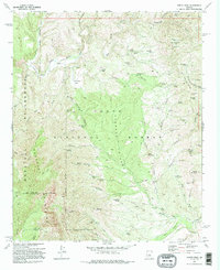
1973 Map of North Peak
USGS Topo · Published 1995About this map
The East Verde River and Pine Creek define the northern drainages of this 1970s landscape, where the high desert meets the rugged elevations of the Mazatzal Mountains. Significant mining activity is documented throughout the area, with remote sites such as the Little Green Mine, Excursion Mine, and Zulu Mine scattered across the complex terrain. These operations, often located near seasonal water sources like Little Green Mine Spring, tell the story of mineral exploration within the Tonto National Forest. Settlement is sparse, represented by the Doll Baby Ranch and the open ground of Simonton Flat. Moving south toward North Peak, the map traces the Mazatzal Divide Trail as it winds along the ridge, providing a clear view of the historical trail systems and cattle infrastructure, including the Hi Windmill and numerous named water tanks like Gold Hill Tank that supported ranching in this demanding environment.
Find a feature on this map
81 named features on this map. Tap any name to fly to it.
Don’t see what you’re looking for? This feature index may not catch every label — zoom into the map to look around manually.
Map Details
Editions of this 1973 North Peak Map
3 editions found
Other maps of this area

1887 · Verde
USGS Topo · 1:250,000

1892 · Verde
USGS Topo · 1:250,000

1929 · Turret Peak
USGS Topo · 1:125,000

1933 · Turret Peak
USGS Topo · 1:125,000

1934 · Pine
USGS Topo · 1:62,500

1936 · Payson
USGS Topo · 1:48,000

1940 · Pine
USGS Topo · 1:62,500

1942 · Payson
USGS Topo · 1:62,500

1952 · Pine
USGS Topo · 1:62,500

1954 · Holbrook
USGS Topo · 1:250,000