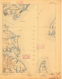
1893 Map of North Point
USGS Topo · Published 1896About this map
The Patapsco River and northern Chesapeake Bay define this 1890s survey of the maritime approaches to Baltimore. The industrial character of the shoreline is evident at Steelton and Sparrow Pt., while the southern reaches of Anne Arundel reveal a more rural, creek-dissected landscape. Navigational markers like the Seven Foot Knoll Light and the Craighill Channel Front Light highlight the critical importance of these waters for late 19th-century shipping. Along the eastern shore, the map documents established maritime outposts such as Rock Hall Landing and Kent Landing on Kent Island. Inland, small community hubs like Jacob Store and St Margaret appear alongside family-named points and coves, offering a detailed view of the region's topography before mid-century suburbanization changed the character of the bay's western neck.
Find a feature on this map
54 named features on this map. Tap any name to fly to it.
Don’t see what you’re looking for? This feature index may not catch every label — zoom into the map to look around manually.
Map Details
Editions of this 1893 North Point Map
3 editions found
Other maps of this area

1892 · Owensville
USGS Topo · 1:62,500

1892 · Annapolis
USGS Topo · 1:62,500

1893 · North Point
USGS Topo · 1:62,500

1893 · Gunpowder
USGS Topo · 1:62,500

1894 · Baltimore
USGS Topo · 1:62,500

1894 · Relay
USGS Topo · 1:62,500

1895 · Owensville
USGS Topo · 1:62,500

1898 · Choptank
USGS Topo · 1:125,000

1898 · Tolchester
USGS Topo · 1:125,000

1899 · Patuxent
USGS Topo · 1:125,000