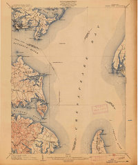
1904 Map of North Point
USGS Topo · Published 1913About this map
Sparrow Point and the industrial activity at Chesapeake Mills dominate the northern shoreline of this survey, which captures the complex maritime landscape of the lower Patapsco River and the upper Chesapeake. The map details a period when the region's defense and navigation were central to its identity, featuring Fort Howard on North Point and Fort Smallwood guarding Rock Point. The intricate network of tidal creeks and peninsulas, including Hog Neck and Bodkin Neck, reveals a coastal economy of landings and wharves such as Wilsons Whf. and Gratitude Landing.
Find a feature on this map
94 named features on this map. Tap any name to fly to it.
Don’t see what you’re looking for? This feature index may not catch every label — zoom into the map to look around manually.
Map Details
Editions of this 1904 North Point Map
5 editions found

Other maps of this area

1892 · Owensville
USGS Topo · 1:62,500

1892 · Annapolis
USGS Topo · 1:62,500

1893 · North Point
USGS Topo · 1:62,500

1893 · Gunpowder
USGS Topo · 1:62,500

1894 · Baltimore
USGS Topo · 1:62,500

1894 · Relay
USGS Topo · 1:62,500

1895 · Owensville
USGS Topo · 1:62,500

1898 · Choptank
USGS Topo · 1:125,000

1898 · Tolchester
USGS Topo · 1:125,000

1899 · Patuxent
USGS Topo · 1:125,000