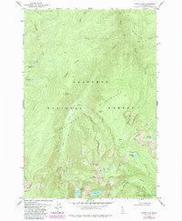
1979 Map of North Pole
USGS Topo · Published 1987About this map
The high-altitude mining and wilderness landscape of Idaho County is documented here during the late 1970s and 1980s. Centered on the towering North Pole summit, the terrain is defined by the steep ridges and alpine basins of the Gospel Hump region within the Nez Perce National Forest. The map captures a moment when mining history and primitive recreation converged, evidenced by the North Star Mine and Wiseboy Mine located near the headwaters of Wiseboy Creek. Scattered Ruins and a Prospect further indicate the area's prospecting legacy.
Find a feature on this map
39 named features on this map. Tap any name to fly to it.
Don’t see what you’re looking for? This feature index may not catch every label — zoom into the map to look around manually.
Map Details
Editions of this 1979 North Pole Map
This is the sole edition of this map. No revisions or reprints were ever made.
Other maps of this area

1931 · Buffalo Hump
USGS Topo · 1:125,000

1934 · Buffalo Hump
USGS Topo · 1:125,000

1956 · Elk City
USGS Topo · 1:250,000

1960 · Elk City
USGS Topo · 1:250,000

1962 · Golden
USGS Topo · 1:24,000

1962 · Center Star Mtn
USGS Topo · 1:24,000

1963 · Sourdough Peak
USGS Topo · 1:24,000

1963 · Huddleson Bluff
USGS Topo · 1:24,000

1963 · Marble Butte
USGS Topo · 1:24,000

1977 · Silver Spur Ridge
USGS Topo · 1:24,000