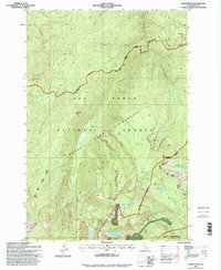
1995 Map of North Pole
USGS Topo · Published 1999About this map
Nez Perce National Forest provides the setting for this detailed survey of the high backcountry, centered on the aptly named North Pole summit. The landscape is defined by the high-elevation drainage systems of Twentymile Creek and Tenmile Creek, where the timberline gives way to ridges like Bear Grass Ridge and Williams Creek Ridge. Historical remnants of early 20th-century resource extraction are visible near the southern boundary, where the North Star Mine, Wiseboy Mine, and various prospects are documented alongside scattered Ruins.
Find a feature on this map
36 named features on this map. Tap any name to fly to it.
Don’t see what you’re looking for? This feature index may not catch every label — zoom into the map to look around manually.
Map Details
Editions of this 1995 North Pole Map
This is the sole edition of this map. No revisions or reprints were ever made.
Other maps of this area

1931 · Buffalo Hump
USGS Topo · 1:125,000

1934 · Buffalo Hump
USGS Topo · 1:125,000

1956 · Elk City
USGS Topo · 1:250,000

1960 · Elk City
USGS Topo · 1:250,000

1962 · Golden
USGS Topo · 1:24,000

1962 · Center Star Mtn
USGS Topo · 1:24,000

1963 · Sourdough Peak
USGS Topo · 1:24,000

1963 · Huddleson Bluff
USGS Topo · 1:24,000

1963 · Marble Butte
USGS Topo · 1:24,000

1977 · Silver Spur Ridge
USGS Topo · 1:24,000