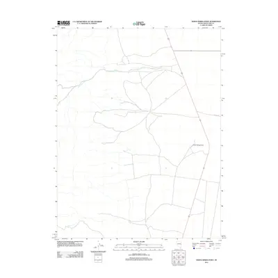
2012 Map of North Spring Point
USGS Topo · Published 2012About this map
John Henry Wash defines much of the hydrologic character of this White Pine County landscape, cutting a wide path across the northern reaches of the quadrangle. The terrain is marked by the distinct elevation of North Spring Point, which overlooks a network of local roads and unimproved tracks in this high desert region. In the southwestern corner, Basin Spring provides a rare water source in an otherwise arid environment dominated by drainage patterns and isolation. The presence of Highline Rd running through the eastern portion of the map suggests a vital corridor for travel and land management in a sparsely populated area of Nevada during the early 21st century.
Find a feature on this map
4 named features on this map. Tap any name to fly to it.
Don’t see what you’re looking for? This feature index may not catch every label — zoom into the map to look around manually.
Map Details
Editions of this 2012 North Spring Point Map
This is the sole edition of this map. No revisions or reprints were ever made.
Other maps of this area
1948 · Wheeler Peak
USGS Topo · 1:62,500
1950 · Wheeler Peak
USGS Topo · 1:62,500
1952 · Ely
USGS Topo · 1:125,000

1956 · Lund
USGS Topo · 1:250,000

1956 · Ely
USGS Topo · 1:250,000

1959 · Ely
USGS Topo · 1:250,000
1959 · Sacramento Pass
USGS Topo · 1:62,500
1959 · Connors Pass
USGS Topo · 1:62,500

1960 · Lund
USGS Topo · 1:250,000

1963 · Ely
USGS Topo · 1:250,000