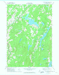
1970 Map of North Whitefield
USGS Topo · Published 1974About this map
The Sheepscot River carves through the landscape of Lincoln County in the early 1970s, serving as a primary corridor for the communities of North Whitefield and Whitefield. This survey emphasizes a water-rich interior defined by numerous lakes and ponds, including Clary Lake, Dyer Long Pond, and the northern reaches of Damariscotta Lake. Local life is anchored by established institutions such as St Denis Ch and the Whitefield Sch, while a network of cemeteries like Trask Lawn Cem and Noyes Cem offers valuable data for genealogists tracing family histories in Jefferson and Alna. The map illustrates a rural Maine economy transitioning through the mid-20th century, with scattered gravel pits and a gaging station alongside traditional farm-to-market roads and family-named elevations like Jones Hill and Weeks Hill.
Find a feature on this map
48 named features on this map. Tap any name to fly to it.
Don’t see what you’re looking for? This feature index may not catch every label — zoom into the map to look around manually.
Map Details
Editions of this 1970 North Whitefield Map
3 editions found
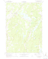
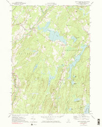
Other maps of this area

1893 · Vassalboro
USGS Topo · 1:62,500

1893 · Wiscasset
USGS Topo · 1:62,500

1898 · Vassalboro
USGS Topo · 1:62,500

1913 · Waldoboro
USGS Topo · 1:48,000

1915 · Waldoboro
USGS Topo · 1:62,500

1916 · Liberty
USGS Topo · 1:62,500

1941 · Waldoboro
USGS Topo · 1:62,500

1941 · Vassalboro
USGS Topo · 1:62,500

1942 · Liberty
USGS Topo · 1:62,500

1943 · Vassalboro
USGS Topo · 1:62,500