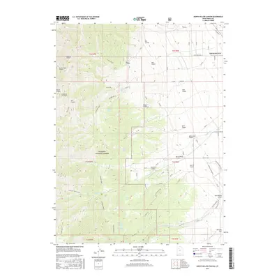
2017 Map of North Willow Canyon
USGS Topo · Published 2017About this map
The Stansbury Crest and the dramatic eastern front of the Stansbury Mountains dominate this 2017 survey of Tooele County. Rising from the outskirts of Grantsville, the terrain quickly ascends into the Wasatch National Forest, where a network of deeply incised drainages like North Willow Canyon and Box Canyon define the landscape. The map reveals a vital mountain-to-valley water system marked by numerous high-elevation water sources including Limekiln Spring, Black Bunch Spring, and White Rock Spring. A history of resource extraction is noted at Mack Canyon, while modern access is provided by several named routes such as Magpie Rd and S Willow Rd, which lead into the canyons and toward the Stansbury Front.
Find a feature on this map
50 named features on this map. Tap any name to fly to it.
Don’t see what you’re looking for? This feature index may not catch every label — zoom into the map to look around manually.
Map Details
Editions of this 2017 North Willow Canyon Map
This is the sole edition of this map. No revisions or reprints were ever made.
Other maps of this area

1885 · Tooele Valley
USGS Topo · 1:250,000

1918 · Stockton
USGS Topo · 1:62,500

1953 · Tooele
USGS Topo · 1:250,000

1955 · Timpie
USGS Topo · 1:62,500

1955 · Deseret Peak
USGS Topo · 1:62,500

1955 · Burmester
USGS Topo · 1:24,000

1955 · Grantsville
USGS Topo · 1:24,000

1955 · Stockton
USGS Topo · 1:62,500

1955 · Tooele
USGS Topo · 1:250,000
1972 · Burmester
USGS Topo · 1:24,000