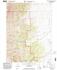
1998 Map of North Willow Canyon
USGS Topo · Published 2001About this map
The high alpine environment of the Stansbury Mountains dominates this late-twentieth-century survey, characterized by deep canyons and critical water sources. Within the protected boundaries of the Deseret Peak Wilderness and the Wasatch National Forest, the landscape is defined by its verticality and drainage systems. The presence of Mines Prospects and a Gravel Pit near the eastern base of the range indicates the historical intersection of recreation and resource extraction in Tooele County.
Find a feature on this map
35 named features on this map. Tap any name to fly to it.
Don’t see what you’re looking for? This feature index may not catch every label — zoom into the map to look around manually.
Map Details
Editions of this 1998 North Willow Canyon Map
This is the sole edition of this map. No revisions or reprints were ever made.
Other maps of this area

1885 · Tooele Valley
USGS Topo · 1:250,000

1918 · Stockton
USGS Topo · 1:62,500

1953 · Tooele
USGS Topo · 1:250,000

1955 · Timpie
USGS Topo · 1:62,500

1955 · Deseret Peak
USGS Topo · 1:62,500

1955 · Burmester
USGS Topo · 1:24,000

1955 · Grantsville
USGS Topo · 1:24,000

1955 · Stockton
USGS Topo · 1:62,500

1955 · Tooele
USGS Topo · 1:250,000
1972 · Burmester
USGS Topo · 1:24,000