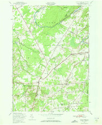
1949 Map of North Wilna
USGS Topo · Published 1973About this map
The Pine Camp Military Reservation dominates the center of this 1949 landscape, carving a massive tactical perimeter through the towns of Wilna, Diana, and Croghan. This military presence reshapes the traditional rural layout, as seen where the Russell Turnpike and Lewisburg Road intersect with strict military boundary lines. Outside the reservation, the surviving agrarian and industrial roots of Jefferson and Lewis Counties remain visible. Small hamlets and named crossroads like Lewisburg, North Wilna, and Ormiston Corners are connected by a network of local routes including the Nauvoo School Road and Street Road. Education is anchored by a numbered system of local schoolhouses, such as Sand Hill School No 5 and School No 9. The Indian River and its tributaries, including Black Creek and Gormley Creek, provide the drainage for this undulating terrain marked by distinctive heights like Barr Hill and Ney Hill.
Find a feature on this map
53 named features on this map. Tap any name to fly to it.
Don’t see what you’re looking for? This feature index may not catch every label — zoom into the map to look around manually.
Map Details
Editions of this 1949 North Wilna Map
2 editions found
Other maps of this area

1902 · Carthage
USGS Topo · 1:62,500

1904 · Carthage
USGS Topo · 1:62,500

1911 · Antwerp
USGS Topo · 1:62,500

1911 · Lowville
USGS Topo · 1:62,500

1913 · Lowville
USGS Topo · 1:62,500

1913 · Lake Bonaparte
USGS Topo · 1:62,500

1916 · Lake Bonaparte
USGS Topo · 1:62,500

1942 · Copenhagen
USGS Topo · 1:24,000

1943 · Copenhagen
USGS Topo · 1:31,680

1943 · Carthage
USGS Topo · 1:31,680