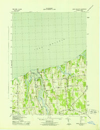
1943 Map of North Wolcott
USGS Topo · Published 1943About this map
The south shore of Lake Ontario defines the landscape of this 1943 survey, where the indented waters of Port Bay and the drainage of Wolcott Creek meet the drumlin-dominated topography of Wayne County. The settlement at North Wolcott serves as a small inland hub, surrounded by a rural infrastructure of numbered school districts, including School No 4 and School No 12.
Find a feature on this map
31 named features on this map. Tap any name to fly to it.
Don’t see what you’re looking for? This feature index may not catch every label — zoom into the map to look around manually.
Map Details
Editions of this 1943 North Wolcott Map
This is the sole edition of this map. No revisions or reprints were ever made.
Other maps of this area

1900 · Oswego
USGS Topo · 1:62,500

1902 · Sodus Bay
USGS Topo · 1:62,500

1902 · Clyde
USGS Topo · 1:62,500

1902 · Weedsport
USGS Topo · 1:62,500

1943 · Sodus Point
USGS Topo · 1:31,680

1943 · Fair Haven
USGS Topo · 1:31,680

1943 · Wolcott
USGS Topo · 1:31,680
1943 · Rose
USGS Topo · 1:31,680
1943 · Red Creek
USGS Topo · 1:31,680
1943 · West Ninemile Point
USGS Topo · 1:31,680