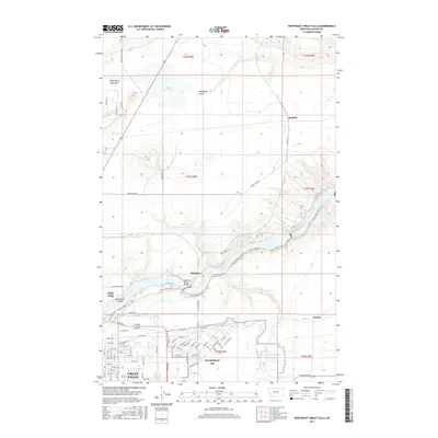
2017 Map of Northeast Great Falls
USGS Topo · Published 2017About this map
The Missouri River carves a dramatic path through this section of Great Falls, defining a landscape where industrial heritage and natural landmarks converge. The river's course is punctuated by Rainbow Falls and Crooked Falls, with Steamboat Island and the lush Giant Springs providing iconic geographical anchors. An extensive network of recreational paths, including the River's Edge Trail and N Shore Trail, traces the rugged river bluffs, connecting the community to these water features. To the south, the sprawling grounds of Malmstrom AFB dominate the plateau, while the residential grids of Black Eagle and the outskirts of the city expand toward the rural north. Outlying settlements like Sheffels and Cooper mark the transition into the higher plains, where Black Horse Lake and Blackfeet Gulch characterize the open terrain.
Find a feature on this map
82 named features on this map. Tap any name to fly to it.
Don’t see what you’re looking for? This feature index may not catch every label — zoom into the map to look around manually.
Map Details
Editions of this 2017 Northeast Great Falls Map
This is the sole edition of this map. No revisions or reprints were ever made.
Other maps of this area

1886 · Great Falls
USGS Topo · 1:250,000

1948 · Portage
USGS Topo · 1:62,500

1949 · Portage
USGS Topo · 1:62,500

1949 · Great Falls
USGS Topo · 1:62,500

1951 · Great Falls
USGS Topo · 1:62,500

1954 · Great Falls
USGS Topo · 1:250,000

1955 · Stockett
USGS Topo · 1:62,500

1955 · Gore Hill
USGS Topo · 1:62,500

1957 · Great Falls
USGS Topo · 1:250,000
1965 · Floweree
USGS Topo · 1:24,000