
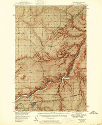
1949 Map of Portage
USGS Topo · Published 1949About this map
The Missouri River carves a deep path through the high plains north of Great Falls, defining the industrial and logistical character of this 1940s landscape. This survey, part of a Department of the Interior program for the development of the Missouri River Basin, documents the significant hydroelectric infrastructure of the era, including the Morony Dam, Ryan Dam, and Rainbow Dam. These power sources supported the growth of the region and the nearby Great Falls Army Air Force Base.
Find a feature on this map
31 named features on this map. Tap any name to fly to it.
Don’t see what you’re looking for? This feature index may not catch every label — zoom into the map to look around manually.
Map Details
Editions of this 1949 Portage Map
2 editions found
Other maps of this area

1886 · Great Falls
USGS Topo · 1:250,000

1890 · Fort Benton
USGS Topo · 1:250,000

1892 · Fort Benton
USGS Topo · 1:250,000

1897 · Fort Benton
USGS Topo · 1:250,000

1948 · Portage
USGS Topo · 1:62,500

1949 · Timber Coulee
USGS Topo · 1:62,500

1949 · Great Falls
USGS Topo · 1:62,500

1950 · Timber Coulee
USGS Topo · 1:62,500

1950 · Dent Bridge
USGS Topo · 1:62,500

1951 · Great Falls
USGS Topo · 1:62,500