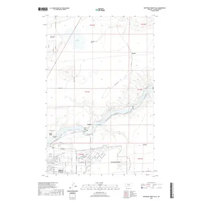
2020 Map of Northeast Great Falls
USGS Topo · Published 2020About this map
The Missouri River carves a deep valley through the northern reaches of Great Falls, defining a landscape of industrial heritage and natural landmarks. This modern survey illustrates the proximity of Malmstrom AFB to the growing residential corridors north of Central Ave. The river's path is marked by a series of hydroelectric and geological features, including the Rainbow Falls and Crooked Falls, which are accessible via the extensive River's Edge Trail and N Shore Trail systems. To the north, the terrain transitions into the more open flats near Black Horse Lake and Sheffels. The map details the transition from the dense urban grid of Black Eagle to the expansive military installation, offering a clear view of how topography and infrastructure have shaped this Montana community.
Find a feature on this map
74 named features on this map. Tap any name to fly to it.
Don’t see what you’re looking for? This feature index may not catch every label — zoom into the map to look around manually.
Map Details
Editions of this 2020 Northeast Great Falls Map
This is the sole edition of this map. No revisions or reprints were ever made.
Other maps of this area

1886 · Great Falls
USGS Topo · 1:250,000

1948 · Portage
USGS Topo · 1:62,500

1949 · Portage
USGS Topo · 1:62,500

1949 · Great Falls
USGS Topo · 1:62,500

1951 · Great Falls
USGS Topo · 1:62,500

1954 · Great Falls
USGS Topo · 1:250,000

1955 · Stockett
USGS Topo · 1:62,500

1955 · Gore Hill
USGS Topo · 1:62,500

1957 · Great Falls
USGS Topo · 1:250,000
1965 · Floweree
USGS Topo · 1:24,000