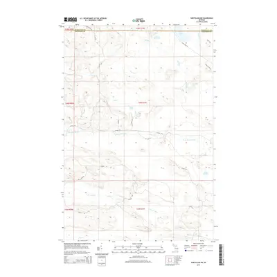
2014 Map of Northland NW
USGS Topo · Published 2014About this map
The W Br Escanaba River and the N Br Ford River dominate the hydrology of this forested region on the border of Marquette and Dickinson counties. The landscape is defined by a dense network of timber and access routes, including the Tower Truck Trl, Moose Country Trl, and Skellys Ranch Rd. These tracks indicate a landscape managed for natural resources and seasonal recreation. Numerous small water bodies like Kates Lake, Cady Lake, and the uniquely named Lake Thirtysix are fed by a complex system of drainage such as Big Brook and Bryan Cr. The prevalence of "Grade" and "Truck Trail" labels suggests the historical influence of logging railroads or early forest management infrastructure that once penetrated these woods, connecting the remote interior to larger transport hubs outside the quadrangle.
Find a feature on this map
30 named features on this map. Tap any name to fly to it.
Don’t see what you’re looking for? This feature index may not catch every label — zoom into the map to look around manually.
Map Details
Editions of this 2014 Northland NW Map
This is the sole edition of this map. No revisions or reprints were ever made.
Other maps of this area

1952 · Ishpeming
USGS Topo · 1:62,500

1955 · Ralph NE
USGS Topo · 1:24,000

1955 · Republic
USGS Topo · 1:62,500

1955 · Ralph
USGS Topo · 1:62,500

1957 · Northland
USGS Topo · 1:62,500

1958 · Marquette
USGS Topo · 1:250,000

1960 · Marquette
USGS Topo · 1:250,000

1961 · Marquette
USGS Topo · 1:250,000

1968 · Marquette
USGS Topo · 1:250,000
1983 · Gwinn
USGS Topo · 1:100,000