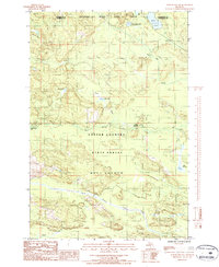
1986 Map of Northland NW
USGS Topo · Published 1986About this map
The Escanaba River State Forest dominates this northern peninsula landscape where the borders of Marquette and Dickinson counties meet. This 1980s provisional survey illustrates a remote timber and recreation area defined by complex water systems, including the West Branch Escanaba River and the Ford River. The map reveals the managed nature of the Upper Peninsula forests during this era, showing how the Copper Country State Forest overlaps these hydraulic networks. Local landmarks like Camp Sanford Campground and various named water bodies such as Kates Lake and the numerically named Lake Thirtysix provide specific points of interest for those studying the region's wilderness usage. The presence of numerous brooks and creeks, including Cady Creek and McGregor Creek, indicates a landscape that remained largely undeveloped and focused on natural resource management and outdoor activity at the time of the photography.
Find a feature on this map
18 named features on this map. Tap any name to fly to it.
Don’t see what you’re looking for? This feature index may not catch every label — zoom into the map to look around manually.
Map Details
Editions of this 1986 Northland NW Map
This is the sole edition of this map. No revisions or reprints were ever made.
Other maps of this area

1952 · Ishpeming
USGS Topo · 1:62,500

1955 · Ralph NE
USGS Topo · 1:24,000

1955 · Republic
USGS Topo · 1:62,500

1955 · Ralph
USGS Topo · 1:62,500

1957 · Northland
USGS Topo · 1:62,500

1958 · Marquette
USGS Topo · 1:250,000

1960 · Marquette
USGS Topo · 1:250,000

1961 · Marquette
USGS Topo · 1:250,000

1968 · Marquette
USGS Topo · 1:250,000
1983 · Gwinn
USGS Topo · 1:100,000