
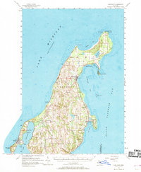
1957 Map of Northport
USGS Topo · Published 1958About this map
The tip of Michigan's Leelanau Peninsula emerges as a landscape of coastal settlements and maritime landmarks in the late 1950s. At the northernmost point, the Grand Traverse Light stands watch over Lighthouse Point, marking the entrance to Grand Traverse Bay. The interior is defined by a series of small, culturally distinct communities, including the village of Peshawbestown and the clustered settlements of Omena and Northport. Cultural heritage is evident in the presence of sites like St Wenceslaus Ch and Indian Ch, alongside several local cemeteries such as Beechwood Cem and East Leland Cem.
Find a feature on this map
46 named features on this map. Tap any name to fly to it.
Don’t see what you’re looking for? This feature index may not catch every label — zoom into the map to look around manually.
Map Details
Editions of this 1957 Northport Map
2 editions found
Other maps of this area

1954 · Central Lake
USGS Topo · 1:62,500

1954 · Charlevoix
USGS Topo · 1:62,500

1954 · Traverse City
USGS Topo · 1:250,000

1955 · Cheboygan
USGS Topo · 1:250,000

1956 · South Fox Island
USGS Topo · 1:62,500

1957 · Traverse City
USGS Topo · 1:62,500

1957 · Maple City
USGS Topo · 1:62,500

1957 · Elk Rapids
USGS Topo · 1:62,500

1958 · Cheboygan
USGS Topo · 1:250,000

1958 · Traverse City
USGS Topo · 1:250,000