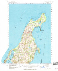
1957 Map of Northport
USGS Topo · Published 1969About this map
Grand Traverse Light stands at the northernmost tip of the Leelanau Peninsula, marking the transition from the open waters of Lake Michigan into the shelter of Grand Traverse Bay. This mid-century coastal landscape is characterized by its cherry-growing heritage and maritime navigation, with significant cultural landmarks such as Peshawbestown and Ahgosatown situated along the eastern shoreline. The map reveals a deeply etched topography where small drainages like Weaver Creek and Ennis Creek flow into Northport Bay. Inland, the map captures the rural life of the era through scattered landmarks like St Wenceslaus Ch, the Indian Ch, and Woolsey Landing Field. From the working docks of Gills Pier to the protected waters of New Mission Bay, the peninsula's settlement patterns are clearly defined by its relationship with the water and the surrounding Leelanau terrain.
Find a feature on this map
45 named features on this map. Tap any name to fly to it.
Don’t see what you’re looking for? This feature index may not catch every label — zoom into the map to look around manually.
Map Details
Editions of this 1957 Northport Map
2 editions found
Other maps of this area

1954 · Central Lake
USGS Topo · 1:62,500

1954 · Charlevoix
USGS Topo · 1:62,500

1954 · Traverse City
USGS Topo · 1:250,000

1955 · Cheboygan
USGS Topo · 1:250,000

1956 · South Fox Island
USGS Topo · 1:62,500

1957 · Traverse City
USGS Topo · 1:62,500

1957 · Northport
USGS Topo · 1:62,500

1957 · Maple City
USGS Topo · 1:62,500

1957 · Elk Rapids
USGS Topo · 1:62,500

1958 · Cheboygan
USGS Topo · 1:250,000