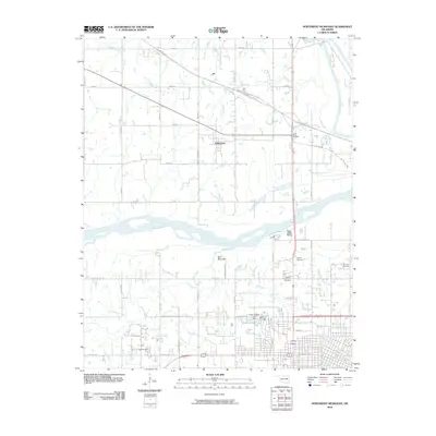
2010 Map of Northwest Muskogee
USGS Topo · Published 2010About this map
Tullahassee stands at the heart of this landscape where the Verdigris River meets the Arkansas River drainage. This region north and west of Muskogee is defined by its diverse water systems, including the winding Big Creek and Pecan Creek. The terrain is punctuated by significant elevations such as Fern Mountain and Agency Hill, which overlook the expanding residential areas and cemeteries that tell the story of local settlement. Several burial grounds, including the Booker T Washington Cemetery and the Jacob Morey Cemetery, provide critical anchors for genealogists and local historians. To the south, the development around Honor Heights and Honor Heights Lake reflects the area's growth, while the Muskogee Tpke and historic routes like Old Taft Rd and Old Porter Rd trace the modern and legacy transportation corridors through the county.
Find a feature on this map
52 named features on this map. Tap any name to fly to it.
Don’t see what you’re looking for? This feature index may not catch every label — zoom into the map to look around manually.
Map Details
Editions of this 2010 Northwest Muskogee Map
This is the sole edition of this map. No revisions or reprints were ever made.
Other maps of this area

1896 · Okmulgee
USGS Topo · 1:125,000

1900 · Okmulgee
USGS Topo · 1:125,000

1901 · Muscogee
USGS Topo · 1:125,000

1905 · Muscogee
USGS Topo · 1:125,000

1946 · Fort Smith
USGS Topo · 1:250,000

1948 · Keefeton
USGS Topo · 1:62,500

1948 · Wagoner
USGS Topo · 1:62,500

1950 · Keefeton
USGS Topo · 1:62,500

1950 · Wagoner
USGS Topo · 1:62,500
1963 · Red Bird
USGS Topo · 1:24,000