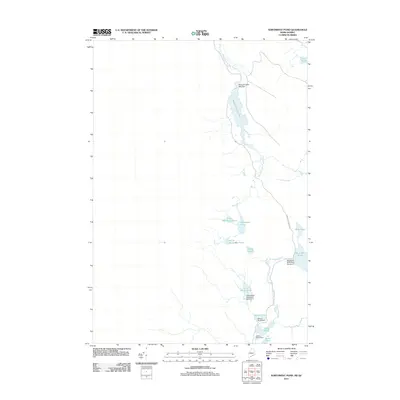
2011 Map of Northwest Pond
USGS Topo · Published 2011About this map
Massachusetts Bog and its associated Massachusetts Bog Stream dominate the northern drainage of this remote borderland terrain between Maine and Quebec. The landscape is defined by a dense network of water management features, including the Massachusetts Bog Dam and numerous numbered structures like Big Island Pond Dam Number 4 and Little Island Pond Dam Number 3. These dams suggest a history of controlled water flow for local industry or timber transport along the Kennebago River. The area is characterized by a series of interconnected ponds such as Northwest Pond, South Boundary Pond, and Little Island Pond. Human infrastructure is minimal, centered primarily on the Kennebago River Rd which follows the river's path, providing access to these isolated waterways.
Find a feature on this map
20 named features on this map. Tap any name to fly to it.
Don’t see what you’re looking for? This feature index may not catch every label — zoom into the map to look around manually.
Map Details
Editions of this 2011 Northwest Pond Map
This is the sole edition of this map. No revisions or reprints were ever made.
Other maps of this area

1928 · Chain Lakes
USGS Topo · 1:48,000

1931 · Cupsuptic
USGS Topo · 1:48,000

1932 · Kennebago Lake
USGS Topo · 1:48,000

1932 · Arnold Pond
USGS Topo · 1:48,000

1932 · Chain Lakes
USGS Topo · 1:62,500

1934 · Cupsuptic
USGS Topo · 1:62,500

1935 · Kennebago Lake
USGS Topo · 1:62,500

1935 · Chain Lakes
USGS Topo · 1:62,500

1935 · Cupsuptic
USGS Topo · 1:62,500

1935 · Arnold Pond
USGS Topo · 1:62,500