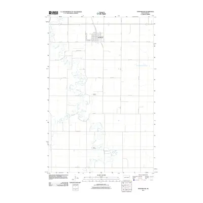
2011 Map of Northwood
USGS Topo · Published 2011About this map
Northwood serves as the primary hub in this eastern North Dakota landscape, organized by the rigid grid of the Red River Valley. The town’s layout is anchored by routes such as Washington Ave and Great North Rd, while the surrounding prairie is defined by the meandering course of the Goose River. This waterway and its tributaries, including Spring Creek and the North Branch Goose River, provide the only topographic relief in an otherwise flat agricultural expanse. For local historians, the map preserves the locations of several community burial grounds that reflect the area's pioneer heritage, including Northwood Cemetery, Lutheran Cemetery, and Bethel Cemetery. The network of section-line roads, such as County Hwy 25 and Eagle Ave, illustrates the persistence of the original land survey system in shaping the modern rural infrastructure.
Find a feature on this map
37 named features on this map. Tap any name to fly to it.
Don’t see what you’re looking for? This feature index may not catch every label — zoom into the map to look around manually.
Map Details
Editions of this 2011 Northwood Map
This is the sole edition of this map. No revisions or reprints were ever made.
Other maps of this area

1934 · Emerado
USGS Topo · 1:48,000

1936 · Emerado
USGS Topo · 1:62,500

1936 · Larimore
USGS Topo · 1:62,500

1952 · Grand Forks
USGS Topo · 1:250,000

1956 · Grand Forks
USGS Topo · 1:250,000

1963 · Kempton
USGS Topo · 1:24,000

1963 · Larimore SW
USGS Topo · 1:24,000

1963 · Emerado SW
USGS Topo · 1:24,000

1966 · Grand Forks
USGS Topo · 1:250,000
1970 · Northwood SE
USGS Topo · 1:24,000