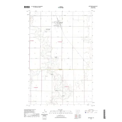
2020 Map of Northwood
USGS Topo · Published 2020About this map
Northwood serves as the primary hub of this landscape, situated near the northern edge of the map where the grid of sections meets the winding course of the Goose River. The terrain is defined by the river’s meandering path and its tributaries, including Spring Cr and the N Br Goose River, which break up the geometric regularity of the surrounding farmland. This area is notably dense with sites of genealogical interest, featuring several rural burying grounds that reflect the region's Scandinavian heritage, such as the Northwood Norwegian Lutheran Cem, Bethel Lutheran Cem, and the Goose River Lutheran Cem. Further south, the Sondreal Graveyard and Berg Field sit along the river's banks. Local infrastructure is anchored by the Northwood Municipal Airport-Vince Field and a network of county roads like Co RD 12 and Co RD 25 that cross the Grand Forks Co and Steele Co border.
Find a feature on this map
46 named features on this map. Tap any name to fly to it.
Don’t see what you’re looking for? This feature index may not catch every label — zoom into the map to look around manually.
Map Details
Editions of this 2020 Northwood Map
This is the sole edition of this map. No revisions or reprints were ever made.
Other maps of this area

1934 · Emerado
USGS Topo · 1:48,000

1936 · Emerado
USGS Topo · 1:62,500

1936 · Larimore
USGS Topo · 1:62,500

1952 · Grand Forks
USGS Topo · 1:250,000

1956 · Grand Forks
USGS Topo · 1:250,000

1963 · Kempton
USGS Topo · 1:24,000

1963 · Larimore SW
USGS Topo · 1:24,000

1963 · Emerado SW
USGS Topo · 1:24,000

1966 · Grand Forks
USGS Topo · 1:250,000
1970 · Northwood SE
USGS Topo · 1:24,000