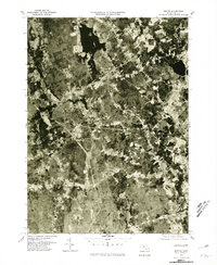
1977 Map of Norton
USGS Topo · Published 1981About this map
Norton Reservoir and the surrounding Bristol County landscape are captured here in high-detail aerial photography from the late 1970s. This orthophotoquad provides an unfiltered view of the region's hydrological network, where the Canoe River feeds into the reservoir, while the Segreganset River and Three Mile River drain the southern reaches. The imagery reveals the distinct textures of suburban development and forest cover at a time of transition for towns like Norton and Westville. These photographs provide a unique layer of information for researchers, showing the exact footprint of residential clusters and rural clearings near Winnecunnet Pond and the northern edge of Taunton. The visual record includes clear views of local road networks and land use patterns that traditional topographic line maps might omit, offering a clear look at the physical environment as it existed just before the 1980s.
Find a feature on this map
10 named features on this map. Tap any name to fly to it.
Don’t see what you’re looking for? This feature index may not catch every label — zoom into the map to look around manually.
Map Details
Editions of this 1977 Norton Map
This is the sole edition of this map. No revisions or reprints were ever made.
Other maps of this area

1885 · Taunton
USGS Topo · 1:62,500

1886 · Dedham
USGS Topo · 1:62,500

1887 · Franklin
USGS Topo · 1:62,500

1887 · Providence
USGS Topo · 1:62,500

1888 · Taunton
USGS Topo · 1:62,500

1889 · Providence
USGS Topo · 1:62,500

1889 · Franklin
USGS Topo · 1:62,500

1893 · Taunton
USGS Topo · 1:62,500

1893 · Franklin
USGS Topo · 1:62,500

1894 · Dedham
USGS Topo · 1:62,500